Images of Tibshelf past
This page is still being developed. More photographs will be added as they become available.
Parish Council Minutes Tibshelf Past Tibshelf Now
The following photos show Tibshelf as it was prior to Second World War and indeed earlier. Photographs of the village as it now, and which will be posted on the site later will show how much, or how little Tibshelf has changed.
|
|
|
|
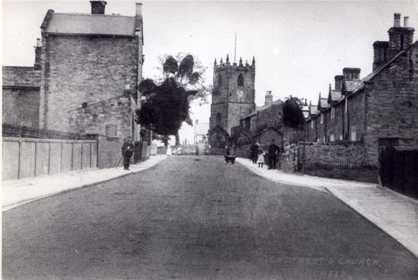
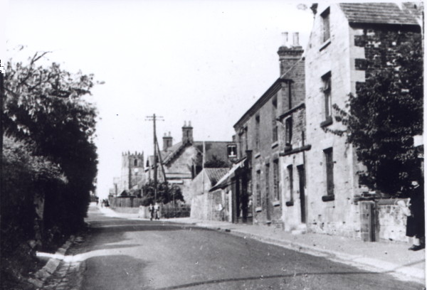
This is the bridge on High Street which carried the main road over the Great Central Railway line from Sheffield to Nottingham. It effectively divided the village in two giving rise to the names Bottom End and Top End for the northern and southern ends of the village respectively. The residents are known as Top Enders and Bottom Enders. The building to the left is the old vicarage, with railway workers cottages to the right. The Parish Church of St. John The Baptist can be seen in the distance. |
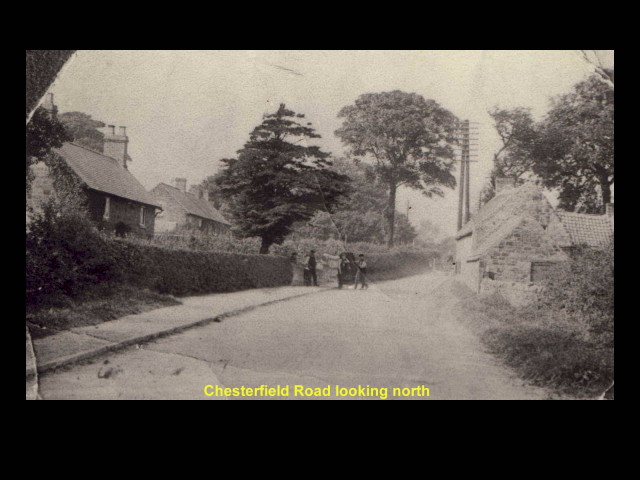
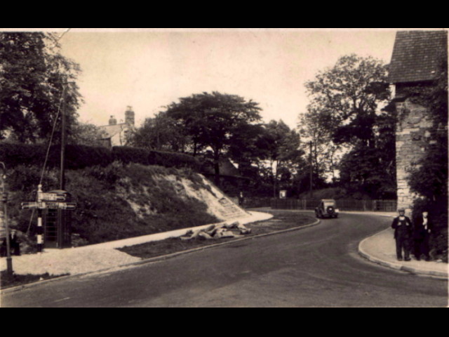
Chesterfield Road, as the name implies, is the main road out of the village (one of five) to Chesterfield some 8 miles to the north. The nearest building on the left was a small shop selling bread, cakes and sweets, amongst other provisions, and was affectionately known as "Waggies" after the proprietor, Mr. Wagstaffe | High Street again, this time a little further south than in the first picture. The buildings on the left are now demolished, a house having been built on the site in the 1950s. Similarly the gable end and the buildings immediately beyond, have also been demolished. The building in the distance is the Wheatsheaf Hotel, whilst in the distance, the Parish Church can just about be seen. | Known locally as Rock House Corner, this is the junction of High Street at its southern end, and where it becomes Doe Hill Lane, with Alfreton Road. The picture was taken in the 1930s/40s after work had begun on the road widening scheme. Rock House Farm can be seen just on the right of the picture. |
|
|
|
|
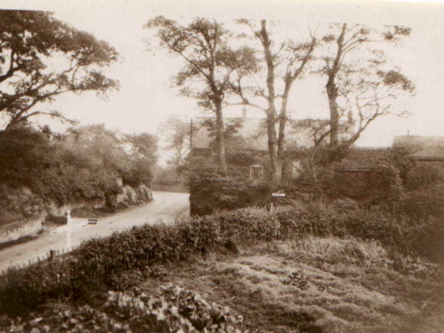
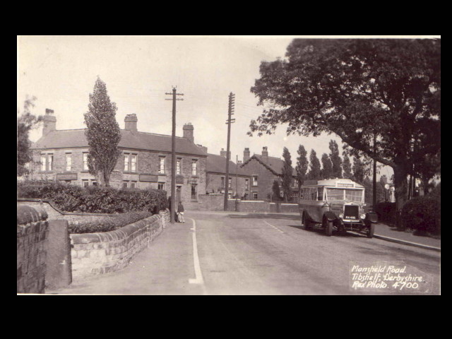
| Rock House Corner again, this time a much earlier picture showing how the road was cut through the rock | One of seven watering holes in Tibshelf can be seen in the background, the White Hart, which stands at the junction of Chesterfield Road to the left, and Mansfield Road. This part of Mansfield Road is now called High Street,. with the former now starting at the road junction with Chesterfield Road. The bus is going to Underwood some10- miles to the south. The buses still stop here. | The White Hart again, this with the view point a little further south, and slightly yo the west, showing Mill Farm and the associated buildings, long since demolished. |
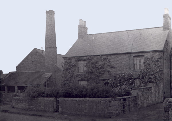
Mill Farm, full on, from then, Mansfield Road.. The house still remains, but all the out buildings have long since disappeared. Originally a steam driven corn mill, I believe. A pond once stood on this site, presumably to provide the water for the mill. |
|
|
|
|
| Taken from outside the Savoy Cinema which stood next door to the "Slap & Tickle" public house. The farm buiilding to right has disappeared, the site now being occupied by a late 20th century bungalow. | Taken from High Street adjacent to the thatched cottage. The farm buildings on the left formed part of Ravenhouse Farm. Most of these buildings have now been demolished. |
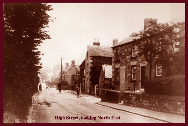
Another view of High Street, probably taken just before or just after World War II. Certainly prior to the widening of Hifg Street because there is no footway on the left hand side of the road. Note the open highway drainage channel. Croft's the Chemists original shop still stands. It was also a provisions and grocery store then, as well as an agricultural supplier. |
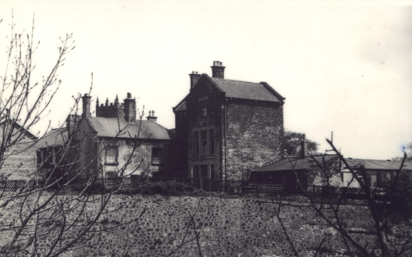
The rear of the original vicarage at the top end of the bridge, demolished in the 1970s. Again not much of this view remains, the railway cutting also having been filled in years ago. A glimpse of the old wooden Church Hall can be seen on the extreme right. |
|
|
|
|
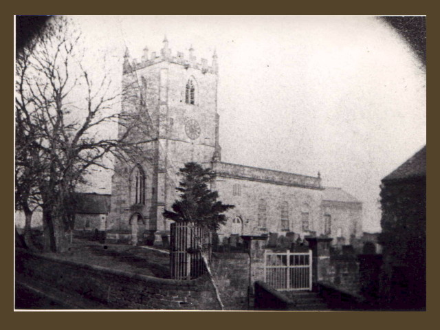
TTibshelf Parish Church prior to its remodelling at the turn of the 19th century. It was then dedicated to SS Peter & Paul, and Tibshelf's feast day is still those saints' day, June 29th. Thats when the wakes used to set up on the old Co-op Field opposite the Post Office, where the flats and the Village Hall now stand |
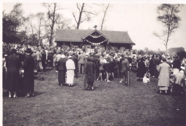
Taken from just below the old telephone exchange, this is Sunny Bank probably in the 1950s. The road was unmade then, just the remaining strech which goes up to the ponds. Origianlly owned by St. Thomas' Hospital, the properties were eventually owned by the Blackwell Rural District Council who demolished them as unfit properties. They would have ben occupied by the miners' who worked at the "Bottom Pit", the slag heap of which can just be discerned in the distance. | Prospect Terrace once stood where the new Staffa Health Centre is located. All that remains in this view is the stone retaining wall. The Off License was oned by the long serving Chesterfield F.C. centre half, Dave Blakey. | Taken on 6th May 1935, the photograph is of the open air service held on the Sports Ground on the occasion of the Silver Jubilee of His Majesty King George V. The chimneys of the original houses on Sunny Bank can just be seen in the background. |
|
|
|
|
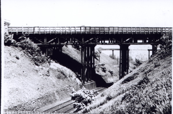
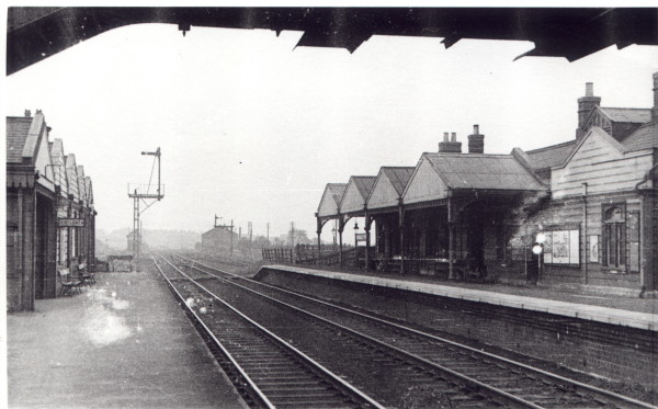
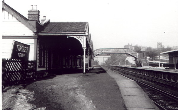
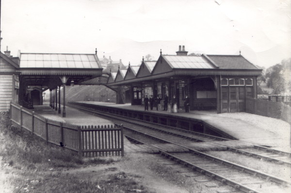
| The old bridge which carried High Street over the railway line. The bridge was replaced around 50 years ago when it became unsafe. Passengers travelling on the upper deck of buses passing over it, had to walk over the bridge in order to spread the load. Its replacement, which was a then, state of the art construction still stands, and will have soon have lasted longer than the original structure. | Tibshelf Town Station looking south. Originally the Great Central Railway, then the L. N. E. R. In the distance can be seen the goods shed and signal box.The Station buildings to the right were replaced in the 1950s by a smaller shelter type structure. From here the line went to Nottingham Victoria via Kirkby Bentinck, Hucknal Tokard and New Basford. | Tibshelf Town Station looking north sometime between 1960 and 1967. The old Vicarage is still standing as is the Church Hall, but the old cottages have already been replaced by the flats on High Street. The next station was Pilsley, thence to Chesterfield Central via Heath. By this time the station had undergone some changes. | Another view of Tibshelf Station, this time much earlier, and judging from the posed station staff, probably an official Great Central Railway photograph. The canopies are much larger here, extending to the edge of the platform. |


|
|
|
|
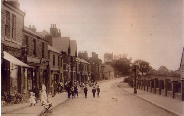
| Judging by the fashions, this photograph was probably taken before the First World War. This part of High Street was then known as Staffa Street, the view point being just above the Tibshelf Equitable Co-operative Society's main shop. opposite the infants' school. All these buildings remain today, although some have changed, and for the better, needing to combat the scourges of crime and vandalism. | An aerial view of High Street just below the bridge. The Derwent Drive/ Peveril Road estate isn't there so it has to be pre-1955. Also missing are the council bungalows on Back Lane. The little cottage which was dated around 1627 was replaced by a modern bungalow many years ago. It would have probably been a Listed Building had it survived the demolition madness of the 50's through to the 70's. | A very early photograph taken outside a new looking "Wheatsheaf". What was the parade for? Kinf Edward VII's Coronation, Queen Victoria's Jubilee, Victory Parade at the end of the First World War, Whit Sunday Walk, Carnival? Any ideas? Please let us know. | No historic photographic record of Tibshelf would be complete without an image of what is probably the best known building in the village after the Church. Judging by the fashions on the posed residents, this photograph probably dates back to the 1920s at the very latest. Until very recently, the cottage which dates back to the 1600s, only had thatch to the front of the roof, the rear being pantiles. It is one of only three Listed Buildings in the village. |


|
|
|
|
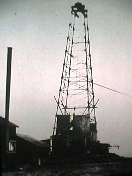
Tibshelf's main claim to fame is the location of the first land based oli well in the UK being with the parish boundaries. The well was sunk in the early 1920s, producing small amounts of high quality oil. Production ceased in the 1930s although it recommenced during the Second World War to asist with the war effort. Production ceased with the end of hostilities. All that remains is a storage tank and various pieces of pipework. |
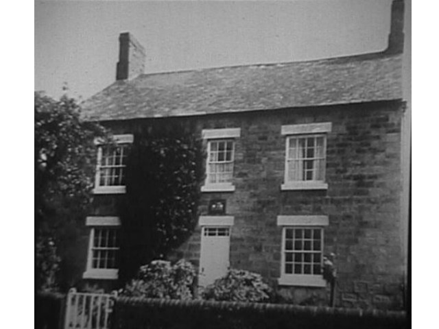
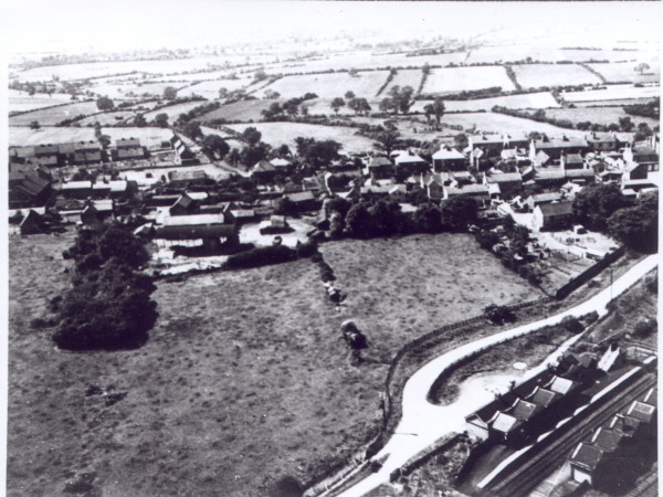
Town Farm house on High Street, prior to alterations. Didn't it look a handsome house with the chimneys still on it? May be someday, a sympathetic owner will put them back and restore the building to its former glory. | Another aerial view this time takem from over the railway line. Tibshelf Twon Station layout can be seen very clearly. The fields on the left are now built on; the Staffa Drive estate. It can also be seen, that whilst West View had alraeadt been built, the Derwent Drive estate had not. This dates the photo to the very early 1950s.The Savoy cinema is also visble on the extreme left | |